


Tag: Navman

Mio Navman announces Spirit TV range
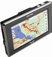
We gave you a sneak preview last month but now it’s official. The first satnav with a built-in TV is here. Actually the first two satnavs with built in TV are here as there are two different sized versions – the Mio Navman V735 which has a huge 7-inch screen and its little brother, the V505 which has a 4.7-inch screen.
Apart from the unique TV function, there are plenty of other features to justify the price of £299 for the V735 and £229 for the V505.
Navigation-wise it’s got everything you’d expect from the Mio Navman brand including TruMaps, smart economical routing, traffic data and safety camera data. There’s also a nice walking navigation side to the device with built-in 2D city maps specially designed for pedestrians.
Like other Mio Navman devices it also includes the NavPix geo-tagged photo navigation feature. This feature, combined with the walking navigation maps will come into its own on city breaks.
But you’re not really interested in all that are you? You just want to know about the TV aspect to the device. Well, it’s pretty straight forward – it has a built-in DVT tuner that will work right across Europe. In the UK that means you could pick up the complete Freeview spectrum, signal permitting. There’s a built-in aerial and there is also a socket to plug in a stronger aerial if required.
Obviously it’s not designed to be used whilst driving – that would be very naughty.
Check out our preview video:
For under £300, these models have come in a bit cheaper than we expected. Get yours direct from Mio Navman.

Shiny Video Review: Navman S90i Satellite Navigation System
Navman’s newest GPS range is more about accessibility than new features – changing the external appearance and interface of a gadget oft feared…

Mio C720t GPS system features a digital camera for image navigation
 You can always tell when we consider a product we’re writing about just a tad bit boring, as we minimise the size of the picture and shove it off to the left like so. Sadly, 450pixels-wide pictures of GPS systems just don’t work as well as iRobot ConnectRs.
Mio’s latest GPS navigation device, the C720t features a digital camera – 2-megapixels to be exact – which allow you to embed GPS coordinates into an image and help you find your way back to the location as if it were an address. Navigadget, the site where we stole this story fromare kindly linking back to, claim…

Shiny Video Preview: Navman S series satellite navigation systems
Last night, Navman debuted their entirely new sat nav system. They’ve made so many improvements it was like Kim’s game just trying to remember all the new features on video. Susi has a bloody good go though, click below. And if you want all the details, check out this post here…

Interview: Navman's Colin Holloway on the future for GPS satnav devices
 One of the themes at this year’s 3GSM show in Barcelona was mobile navigation, buoyed by the fact that GPS is making its way into mobile phones, along with the mapping and applications to make use of it. Naturally, every company in this area reckons mobile navigation’s going to be huge.

Navman send a couple to the centre of Europe with NavPix
5px; float: left;"/>Those nutters over at Navman obviously weren't content with compiling a list of the top ten places where the sat-nav system can take you for Valentine's Day, they've only gone and sent a husband-and-wife team off around…

Navman launches Valentine's Top 10 NavPix guide
Ah, February 14th. The day when you deluge your loved one in flowers, chocs and perfume, then whisk them away on a romantic date. Or just order a Chinese. But if you're stuck for ideas about where to take your…